
Nature at its Finest
Trillium is a nature lover’s paradise, with its beautiful mountain scenery and a wealth of outdoor activities to enjoy. So whether you’re an avid hiker or fisherman or simply love to explore the great outdoors, Cashiers has something for everyone.
Appalachian Fishing
Top Streaming Service
Amateurs and professionals alike have fished our waters, and numerous options are available for anglers of all levels. Beginners may wish to start with an introductory course by one of the region’s excellent fishing schools, while the more experienced may head out on their own or join one of the fishing expeditions hosted by experts and sponsored by one of the clubs or organizations.
Some of our neighboring states also contain excellent fly fishing trout waters also, and with our proximity to Tennessee, Virginia, West Virginia, and Georgia, you can use the greater Cashiers area as your base of operations while exploring endless fishing possibilities.
Go Explore
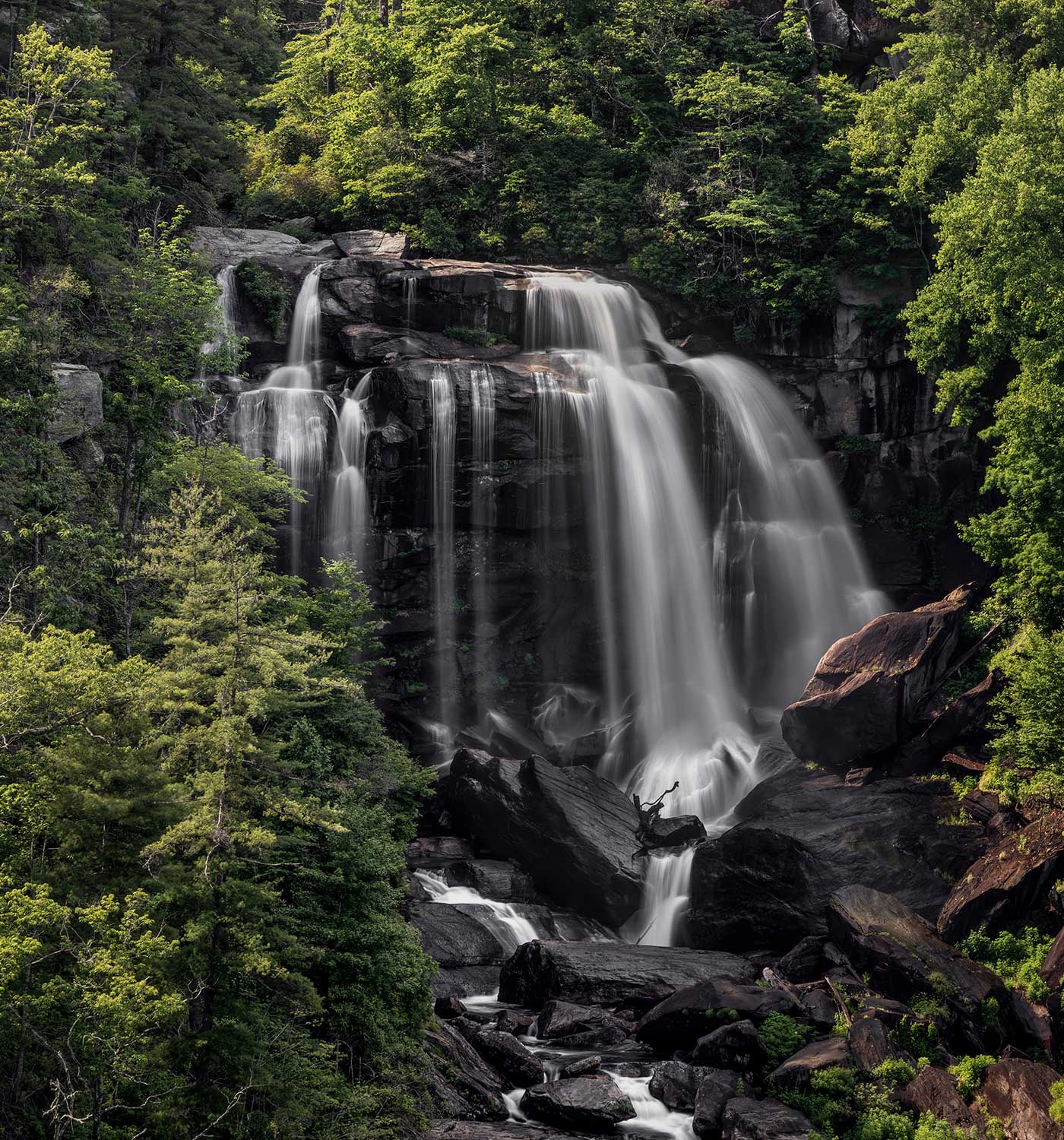
Cashiers, North Carolina, is a hiker’s paradise, offering some of the most breathtaking hiking trails in the Southeast. With its pristine forests, approximately 250 cascading waterfalls within a 50-mile radius, and stunning mountain vistas, Cashiers has something for hikers of all skill levels.
Local Hikes
No matter what your hiking preferences are, Cashiers, North Carolina, has something to offer to everyone who loves to explore the great outdoors. So come and discover the stunning natural beauty of the Cashiers Mountains on one of our many hiking trails.
Below are a few trails to explore!
Length and Difficulty: 1.5 miles, moderate
Offers many short or long hikes to spectacular vistas, such as Scaly Mt., Jones Knob, and Whiterock Mountain. This national recreation trail runs across the mountains of South Carolina, Georgia and North Carolina. It stretches nearly 80 miles from Highlands to Cheoah Bald, east of Robbinsville. Blazed in yellow in Nantahala National Forest, the trail is named after William Bartram, a naturalist who roamed the Southern woods in 1775.
Directions: Take Hwy. 106, 5.7miles to the Osaga Mtn. Vista, park at the overlook. The trail starts across the road, the length is 1.5 miles each way and the climb is over 1000 feet. After quite a climb, the trail levels off and comes to an intersection. The Bartram with yellow blazes, continues up to Scaly summit. The spur trail on right with blue blazes leads to trailhead at Hickory Knut Gap.
Length and Difficulty: 2 miles, easy
Take a leisurely walk through the woods and then along the Chattooga River. This hike features beautiful views of rock formations from the Bull Pen Bridge, known as “The Iron Bridge”. This is a great spot to take photographs. The Chattooga Loop Trail is a very short portion of the longer Chattooga Trail.
Directions: From the intersection of Highway 107 and Highway 64 in Cashiers, travel south on Highway 107 for 7 miles. Turn right onto Bull Pen Road and drive 5.4 miles to the Bull Pen Bridge. The trailhead is on the right, on the far side of the bridge.
Length and Difficulty: 2.9 miles, moderate
Also known as the Chattooga Cliffs Trail, the Chattooga Narrows Trail is a portion of the longer and more difficult Chattooga Trail.
Directions: From the intersection of Highway 107 and Highway 64 in Cashiers, travel south on Highway 107 for 1.7 miles. Turn right onto Whiteside Cove Road and drive 6.8 miles to the Jackson/Macon county line. Look for the Highlands Fire District sign, and park on the left.
Length and Difficulty: 7 miles each (round trip), moderate
Take the Ellicott Wilderness Trail to the Chattooga River and “Ellicott’s Rock.” This area covers over 9,000 acres entering parts of N.C., S.C. and GA. We recommend this trail to more experienced hikers. When the river is in view, you’ll notice a narrow trail that goes off to the left and steeply down the gorge, AVOID this trail, especially if you have smaller children. Allow for plenty of exploring time once you arrive at the river and it’s West bank. This river offers great trout fishing, so you may want to pack some fishing equipment with you, as well as some river shoes, picnic lunch and towels/change of clothes.
Directions: From main intersection of U.S. Hwy- 64/ N.C. Hwy-28 in Highlands, NC drive through main street until the road turns into Horse Cove Road (just past Mtn. Fresh Grocery on your Right). Drive for 4.5 miles until you come to a fork in the road at a Brown mileage sign. Take the Right onto “Bull Pen Rd.” for 2 miles to the entrance to Ellicott Rock Wilderness and the trailhead.
Length and Difficulty: 5.6 miles, moderate
Nicknamed the “Yosemite of the East”, Panthertown Valley is a hiker’s dream. Tucked away in Nantahala National Forest, it covers 6,700 acres and features incredible granite domes and cliffs, major waterfalls, numerous creeks, endangered plant species and rare high altitude bogs. Breathtaking views from the cliffs overlook the entire valley floor. Some of the trails are dangerous and not clearly marked, so it is very important to use a map and stay on the main trails. Fishing, camping and mountain biking are permitted.
Directions: From the intersection of Highway 107 and Highway 64 in Cashiers, take Highway 64 East for 2 miles. Turn left onto Cedar Creek Road and continue for 2.3 miles. Turn right onto Breedlove Road and drive 3.4 miles to the parking area.
Length and Difficulty: 2 miles, moderate
Whiteside Mountain rises to an elevation of 4,930 feet and is about 400 million years old. The mountain’s distinctive rock faces look like sheets of blue-gray ice. A popular short hike, Whiteside Mountain Trail is a loop that runs across the tops of these 750-foot cliffs and offers many outstanding views to the east, south and west. Rare Peregrine falcons and many varieties of colorful wildflowers make their home on this stunning mountain.
Directions: From the intersection of Highway 107 and Highway 64 in Cashiers, drive 4.7 miles west on Highway 64, and turn left on Whiteside Mountain Road at the brown Whiteside Mountain Trail sign. Continue for 1.1 miles, passing Wildcat Cliffs Country Club on the right, and turn into the gravel parking area.
Length and Difficulty: 9.6 miles, difficult
At 5,127 feet above sea level, Yellow Mountain is one of the highest mountains in the Highlands Ranger District. Yellow Mountain Trail takes you to the top, where you will enjoy an unbelievable 360-degree view from the Yellow Mountain Fire Tower. The Civilian Conservation Corps and the US Forest Service built the fire tower in 1934; in the early 1990’s, the tower was revitalized and in 1992 was recognized as a National Historic Lookout. The trail showcases a variety of trees, flowers and berries. This strenuous hike is well worth the trip but is not appropriate for beginners.
Directions: From the intersection of Highway 107 and Highway 64 in Cashiers, drive 7.3 miles west on Highway 64. Turn onto Buck Creek Road and go 2.3 miles to Cole Gap, passing Chestnut Hill on the right. Look for a steep path on the right with a small wooden sign and steps leading to the trail. Parking is on the left in the gravel.
Notice: This is information only. To ensure an enjoyable hike, we strongly recommend you contact the US Forest Service at (828) 526-3765 or visit their office. They have additional information, maps and brochures. Please use caution; although these trails, waterfalls, and scenic areas are beautiful to see, they can be very dangerous.
Please follow these basic rules when hiking:
- Stay on the marked trail; avoid shortcuts
- Stay behind guard rails and heed all caution signs
- Do not climb on boulders
- Tread carefully to avoid stepping on plants and flowers; leave them as you found them for others to enjoy
- Dispose of garbage properly
- Keep dogs on leashes
- Do not drink or carry alcoholic beverages; it is illegal
